Photographs: Courtesy Maharashtra Tourism Maharashtra Tourism
On the state's 53rd birthday, a slice of history courtesy Maharashtra Tourism.
What better way to celebrate the formation of the state than offer a glimpse of its history, right? In the pages to follow we bring you stunning photographs of the state's majestic forts.
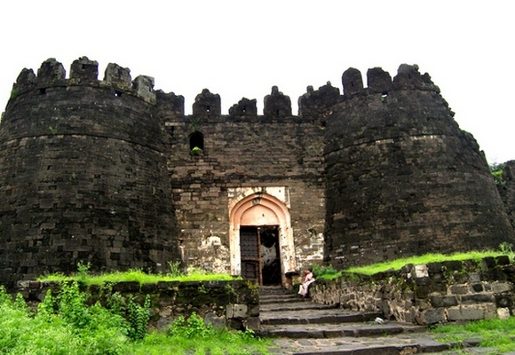
Daulatabad Fort
Devagiri (Daultabad of the later period), 11km north-west of Aurangabad, is a famous for its formidable hill fort.
The fort is situated on an isolated cone-shaped hill rising abruptly from the plain to the height of about 190 metres.
Its fortification constitutes of three concentric lines of defensive walls with large number of bastions.
Among the noteworthy features of the fort are the moat, the scarp and the subterranean passage, all hewn of solid rock.
The upper outlet of the passage was filled with an iron grating, on which a large fire could be used to prevent the progress of the enemy. Among the important structures within the fort are the Chand Minar, the Chini Mahal and the Baradari.
Standing tall at about 63 metres in height, the Chand Minar was erected by Alauddin Bahman Shah in 1435 AD to conquest of Daulatabad. Opposite the Minar is the Jumma masjid, whose pillars originally belonged to a temple. Close to it is a large masonry tank.
The Chini Mahal at the end of the lower for is the place where Abdul Hasan Tana Shah, the last king Golconda, was confined by Aurangzeb in 1687 AD.
Nearby is a round bastion topped with a huge canon with ram's head, called Kila Shikan or Fort breaker.
The Baradari, octagonal in shape, stands near the summit of the fort. The principal bastion at the summit also carries a large canon.
Though the city of Devagiri was founded in 1187 AD by the Yadava king Bhillan V, the fort was constructed during the reign of Singhana II (1210-46 AD).
It was captured by Ala-ud-Din Kalji in 12 94 AD, marking the first Muslim invasion of the Deccan.
Finally in 1318 AD, Malik Kafur killed last Yadava Raja, Harapal. Then in 1327 AD, Muhammed-bin-Tughluq sought to make it his capital, by transferring the entire population of Delhi and changing the name from Devagiri to Daulatabad.
At the time it was in the possession of the Bhamanis till 1526 AD. The fort remained in Mughal control till Aurangzeb's death in 1707 AD., when it passed on to the Nizam of Hyderabad. The famous Ellora Caves are just 16km away from Devagiri-Daulatabad.
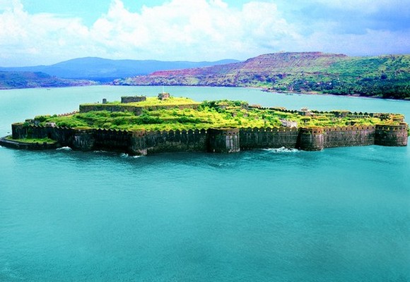
Murud-Janjira
Image: Murud-Janjira FortPhotographs: Courtesy Maharashtra Tourism
Situated on a rock of oval shape near the port town of Murud, 165km south of Mumbai, Janjira is one of the strongest marine forts of India (the word 'Janjira' is a corruption of the Arabic word Jazira for island).
The fort is approached by sail boats from Rajapuri jetty. The main gate of the fort faces Rajapuri on the shore and can be seen only when one is quite close to it. It has a small postern gate towards the open sea for escape.
All of its 19 rounded bastions are still intact.
There are many canons of native and European make rusting on the bastions.
Now in ruins, the fort in its heyday had all necessary facilities, eg, palaces, quarters for officers, mosque, a big fresh water tank, etc.
On the outer wall flanking the main gate, there is a sculpture depicting a tiger-like beast clasping elephants in its claws. This sculpture, its meaning difficult to interpret, appears on many fort-gates of Maharashtra.
Originally the fort was small wooden structure built by a Koli chief in the late 15th century. It was captured by Pir Khan, a general of Nizamshah of Ahmednagar. Later the fort was strengthened by Malik Ambar, the Abyssinian Siddi regent of Ahmednagar kings.
From then onward Siddis became independent, owing allegiance to Adilshah and the Mughals as dictated by the times. Despite their repeated attempts, the Portuguese, the British and the Marathas failed to subdue the Siddi power.
All of Shivaji's attempts to capture Janjira fort failed due to one reason or the other. When Sambhaji also failed, he built another island fort, known as Kansa or Padmadurg, just 9kms north of Janjira. The Janjira state came to an end after 1947. The palace of the Nawabs of Janjira at Murud is still in good shape.
Maharashtra Day: Stunning pictures of majestic forts
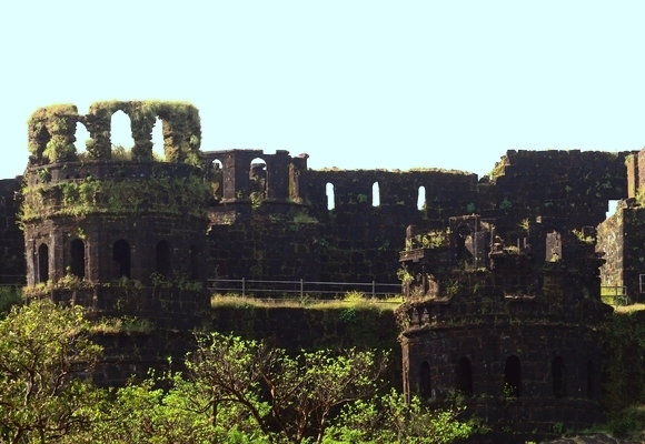
Image: Raigarh FortPhotographs: Courtesy Maharashtra Tourism
Raigarh was Shivaji's capital, the hill fort where he was crowned (1674 AD) and where he died (1680 AD). Strategically situated on an irregular wedge-shaped mass of rock, detached from the main body of Sahyadri Mountains by a deep valley and inaccessible from three sides, Raigarh is 210km south of Mumbai and 27km north of Mahad.
The fort's 5.1sq km hill-top plateau has three main points Hirakani in the west, Takamak in the north and Bhavani in the east. There is only one pathway to Raigarh, probably in keeping with Shiviaji's strategy 'the fort's approach should be easy for friends and impossible for foes'.
A motorable road leads to Chit Darwaja, about 2kms from Pachad, the village at the base, where lies the Samadhi of Jijabai, Shivaji's mother. A long climb from Pachad takes one to the Mahadarwaza, flanked by two massive bastions and a high curtain wall.
The top plateau is covered with a large number of remains of buildings and reservoirs. Behind the Ganga Sagar reservoir are two high towers, in Muslim style.
Behind the towers is the Balekilla or citadel, entered by the Palakhi-darwaza.
On way to the right are remains of chambers of women of Royal families and on the left those of the Darbar of Shivaji. On a low mound in the centre is the site of Shivaji's throne.
Further north is the two-row market place, the Jagadishwar temple in an enclosure and the Samadhi of shivaji, and also that of his favourite dog, Waghya.
The history of Raigarh, earlier known as Rairi, is obscure. In the 12th century Rairi was a seat of the Shirke-Palegar family. After changing several hands, it was captured by Shivaji from Chandrarao More in 1656 AD.
Shivaji chose Rairi for his capital and renamed it as Raigarh. The gigantic construction work was entrusted to Abaji Sondeve and Hiroji Indulkar. In its heyday Raigarh had more than 300 houses and structures.
After Shivaji, the fort remained in the hands of Sambhaji till 1689 AD, when it was captured by the Mughals. Reverted to the Marathas in 1735 AD, Raigarh was surrendered to the British in 1818 AD.
Maharashtra Day: Stunning pictures of majestic forts
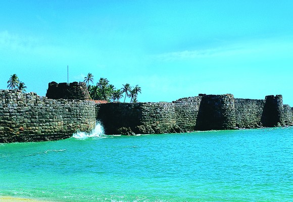
Image: Sindhudurg FortPhotographs: Courtesy Maharashtra Tourism
Sindhudurg fort stands on a rocky island, known as Kurte, barely a km, from the Malavan is 510kms south of Mumbai and 130km north of Goa.
Sindhudurg was built in 1664-67 AD by shivaji when all his attempts to take the island fort of Janjira proved futile. The construction was done under the supervision of Hiroji Indulkar, an able architect. Shivaji had invited 100 Portuguese experts from Goa for the construction of the fort.
It is also recorded that 3000 workers were employed round the clock for three years to build Sindhudurg. It was the body from the Sack of Surat that went into the building of Sindhudurg.
One of the best preserved forts of the Marathas, the 48-acre Sindhudurg fort has a four kms long zigzag line of 9 metres high and 3 metres wide rampart with 42 bastions.
Apart from the huge stones, the building material involved 2000 khandis (72,576kg) of iron erecting the massive curtain wall and bastions. A notable feature is that the foundation stones were laid down firmly in molten lead.
The fort is approachable from the Malavan pier by a boat through a narrow navigable channel between two smaller islands of Dhontara and Padmagad. The main gate, flanked by massive bastions, faces the city.
On the parapet, close to the entrance, under two small domes Shivaji's palm and footprint in dry lime are preserved.
Also in the fort is a temple dedicated to Shivaji -- the only one of its kind in the country -- where stands an image of Shivaji without his trademark beard!
The fort also has houses of some 20 Hindu-Muslim hereditary families.
On a rocky island between Sindhudurg and the coast stood the small for of Padmagad, now in ruins. It acted as a screen for Sindhudurg and was also used for ship-building.
After Shivaji, Sindhudurg passed through the hands of Rajaram-Tarabai, Angres, Peshwa and the Bhosales of Kolhapur.
It was briefly captured by the British in 1765 AD And was renamed by them as Fort Augustus. Later in 1818 AD, the British dismantled the fort's defence structures.
Maharashtra Day: Stunning pictures of majestic forts
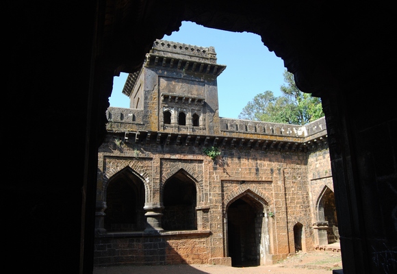
Image: Panhalgarh FortPhotographs: Courtesy Maharashtra Tourism
Panhala or Panhalgarh, about 19kms north-west of Kolhapur, is possibly the largest and most important fort of the Deccan.
Roughly triangular in shape, the hill fort stands at a height of about 850 metres and has a circumference of approximately 7.25km.
Half of its length is protected by a natural scarp reinforced by a parapet wall and the remaining half is surrounded by a strong stone wall strengthened with bastions. The fort had three magnificent double walled gates, out of which two have survived.
The Teen Darwaza to the west is an imposing and powerful structure.
There are a number of ruined monuments in the fort. The most impressive among them are the three huge granaries. The largest among them, the Ganga Kothi, cover nearly 950sq m space and 10.7 metres high. In the north-east corner there is a double story building, called Sajja Kothi, where Shivaji had imprisoned his errant son, Sambhaji.
Panhala was the capital of the Shilahara king Bhoja II during 1178-1209 AD. It was successively held by the Yadava and Bahamani Kings.
In 1489 AD, the fort and the territory was taken over by the Adil Shahi dynasty of Bijapur.
Shivaji seized the fort in 1659 AD. It was from here that Shivaji, when encircled by the forces of Siddi Johar, escaped one rainy night to Vishalgarh. Later, the fort remained with the Marathas, except for a short period in between, when it went to the Mughals.
The fort remained with the Kolhapur State till India achieved independence. Moropanta, the famous Marathi poet (1729-94AD) was bron and brought up at Panhala.
There is also the Samadhi of Ramachandra Amatya, the author of Ajnapatra, an important work on statecraft, including for construction.
Today, Panhala is a sort of hill station and provides all the necessary facilities for tourists.
Maharashtra Day: Stunning pictures of majestic forts
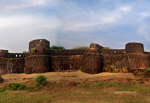
Image: Vijayadurg FortPhotographs: Courtesy Maharashtra Tourism
Vijaydurg, situated 48km south of Ratnagiri, is one of the strongest marine forts on the west coast of India. It is also an excellent harbour.
Built on a hill on the mouth of Vaghotan River, the fort was protected on three sides by the sea and on the east side by ditch, now filled up. After crossing the front gate on the east, the path, skirting round the massive middle wall, enters the hidden inner gateway.
The strong triple line of fortifications had 27 bastions, some of them two-storeyed. Within the citadel there were many buildings and storehouses, now all in ruins except a structure called Rest House. For the supply of water there were several wells and large tanks.
In recent years a submerged wall 100 metres east of the fort has been discovered. The under-sea wall is 3 metres high, 7 metres wide and 122 metres long. How and why this sea-wall was built is not clear. On the bank of the Vaghotan River, about 3km from the fort, there was a wet dock where the Marathas used to build and repair their ships.
Vijayadurg is an ancient site. Initially known as Gheria, it was enlarged by the Bijapur rulers and then strengthened and enlarged in the mid-17th century by Shivaji, to whom it owes its triple line of fortifications, towers and also its new name, Vijayadurg -- the fort of Victory.
During the time of Kanhoji Angre (1667-1729 AD), the naval chief of the Marathas, the fort was so strong and firmly held that it successfully withstood assaults of the European maritime powers.
Later in 1756 AD it fell to the combined operations of the English and the Peshwas. However, it remained in the hands of the Peshwas till 1818 AD when finally it was surrendered to the English.

Comment
article